 English
 العربية
 Deutsch
 Español
 Français
 हिन्दी
 Bahasa Indonesia
 Italiano
 日本語
日本語 한국어
한국어 Polski
 Português (Brasil)
 Русский
 Türkçe
 Українська
 简体中文
简体中文Learn
A light-year would circle Earth 236 million times
The answer to “how far is a light-year in space” is about 9.46 trillion kilometres (5.88 trillion miles), the distance light travels in a year, according to NASA’s definition of a light-year (opens in a new tab). Laid around Earth at the equator, that distance would make about 236 million laps.
A light-year measures distance, not time
The word “year” can mislead: a light-year does not tell how old a star is. It names the distance light travels during a year, describing the gap between a star and Earth. A star’s age and its distance are separate facts; the unit answers the second.
Build up from familiar stretches of land
A football pitch gives a familiar starting point: a FIFA-recommended pitch is 105 m (344 ft) long. The Grand Canyon reaches 29 km (18 mi) at its maximum width, according to the National Park Service’s Grand Canyon FAQ (opens in a new tab). The Colorado River carved most of the canyon, whose exposed rocks record nearly two billion years of geological history. A pitch fits within a field; the canyon’s width stretches across a landscape.
The Salar de Uyuni in Bolivia has a maximum span of 150 km (93.2 mi). It is the world’s largest salt flat, a broad white surface with a far edge you can locate on a map.
That flatness has a practical use. Satellites use the Salar de Uyuni’s exceptionally smooth surface to calibrate altimeters. An altimeter’s readings can be checked against a wide, level surface rather than jagged terrain.
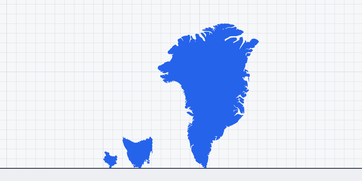
The island state of Tasmania reaches 315 km (196 mi) across. Farther along the scale, the island of Greenland spans 1,050 km (652 mi) east to west, about 3.3 times Tasmania’s maximum width. Greenland’s width is a major crossing on a map, but it still has two sides to travel between.
Each land measurement runs from an edge to another edge: across a pitch, between canyon rims, or from one coast toward another. You can draw that route once and stop at its far end. A circuit is different. It closes back on itself, so the next trip must follow the same path again instead of adding a new stretch of land.
Wrap the distance around Earth
Earth’s equatorial circumference is about 40,075 km (opens in a new tab). Against that planetary loop, a light-year amounts to about 236 million circuits. A single trip around Earth is already a vast route, but it uses only a tiny part of the distance light travels in a year.
Trace the equator on a globe and the route crosses northern South America, the Atlantic, Africa, the Indian Ocean, Indonesia and the Pacific before returning to its starting point. It is not a continuous road: much of the line runs over open water, with continents and islands appearing between ocean stretches. The same coastlines and seas come around again whenever the circuit closes.
Greenland shows why a wide crossing is not the same mental task as a loop. About 80% of the island is covered by ice, leaving a vast frozen interior, but a crossing still ends at a coast. The equatorial route has no far coast where its distance runs out; it returns to its starting point and continues over the same ground and water.
Why the route has to repeat
Thousands of laps sound like an overwhelming itinerary, but the full distance takes hundreds of millions of laps. Crossing Greenland or Salar de Uyuni gives you a start and a finish. The equator gives you a finish that is also the start, with the oceans and continents waiting beneath the same route again.
On a globe, a pencil tracing the equator makes a thin line that closes over itself. It never grows into a wider belt, because every return follows the same path. To show the distance, you would need a separate tally beside the globe, each new mark recording another return to the same starting point.
Related sizes
Things this article is about, with their sizes.
Sources
- NASA Science: What is a light-year? (opens in a new tab) science.nasa.gov
- U.S. National Park Service: Frequently Asked Questions - Grand Canyon National Park (opens in a new tab) nps.gov
- JAXA Earth Observation Research Center: The Salt Flat of Uyuni, Bolivia: The Largest Mirror Lake in the World (opens in a new tab) eorc.jaxa.jp
- Encyclopaedia Britannica — Greenland; National Geographic — Greenland
- Encyclopaedia Britannica — Tasmania; Tasmanian Government — Tasmania at a Glance
- NASA Earth Fact Sheet (NSSDC) (opens in a new tab) nssdc.gsfc.nasa.gov